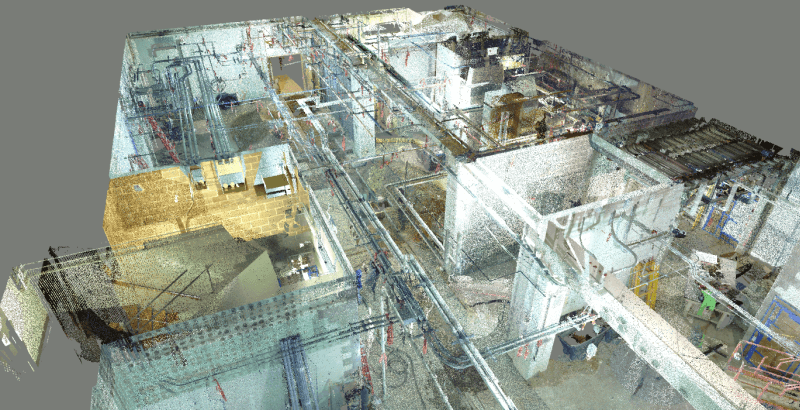
Progress photos argue; point clouds measure. On a mid-size Singapore construction project, the coordination team wanted a monthly record that could settle questions about what was actually built, where, and when, without waiting for a dispute to make the question urgent. Owning a scanner for the programme’s duration did not stack up, so the team settled into a cadence: rent a handheld SLAM scanner from Volumet for a few days each month, scan the site, return the kit, and repeat.
The repeatable walk path
The value of monthly scans comes from comparability, and comparability comes from discipline. The team fixed a walk path in the first month and has repeated it ever since:
- The same start point at the site entrance, beginning in open sky so RTK fixes before the walk.
- The same route through each level, corridor by corridor, in the same order.
- The same loop closures at stair cores, so each month’s trajectory stays internally tight.
- A short checklist noting hoarding moves, new obstructions, and areas that could not be walked, so the next scan explains its own gaps.
A full walk of the accessible works takes under an hour of capture. Because the scanner is handheld and captures while walking, the scan slots between trade activity without stopping work, and a delayed pour or a blocked corridor just becomes a note in the log rather than a rescheduled survey.
Comparing month over month
Each month the team processes the walk into a registered point cloud and drops it into the same project coordinate system, using the RTK georeferencing plus fixed site references to keep every epoch aligned. From there the comparisons are direct: this month’s cloud against last month’s shows what was erected, cast, or removed; cloud-to-cloud distances flag anything that moved when it should not have; and a slice through any gridline shows the state of the structure on a known date.
Coordination with the BIM overlay
The monthly cloud also gets overlaid on the coordination model. Built-vs-designed deviations show up while they are still cheap to fix: services installed off their modelled routes, openings formed slightly off-position, screed levels drifting from design. The team treats the overlay as a coordination reference rather than a certified survey, and flags anything contractual to the project surveyor, but most issues never need to go that far because they are caught within a month of appearing.
Why a dry rental cadence works
After the first rental, which the team paired with Volumet’s optional onboarding session to learn capture technique and file handling, every subsequent month has been a dry rental: equipment only, collected and returned in Singapore. The economics are straightforward. The scanner is on site a few days a month instead of sitting owned and idle for the other twenty-something; there is no maintenance, storage, or firmware upkeep between epochs; and the team books the next slot on the availability calendar as each month’s scan wraps. The capture, the processing, and every dataset belong to the project team; Volumet supplies the hardware and the cadence.
What the record is worth
A year in, the project holds a month-by-month, measurable history of the site: every claim about progress can be checked against geometry, every as-built question has a dated answer, and the eventual handover package includes a progress archive no photo log could match.